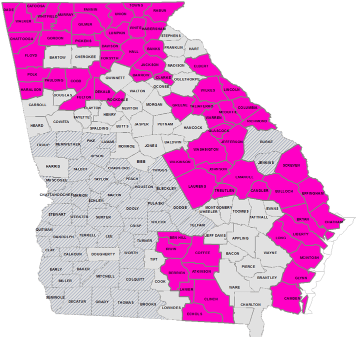
Atlanta, GA (January 10, 2018) – The State of Georgia has been awarded a United States Geological Survey (USGS) 3D Elevation Program grant for the acquisition of elevation data for 67 Georgia counties — over one third of the State. The total commercial value of the award is approximately $5.6 million, of which Georgia partners contributed $1.5 million. The U.S. Department of Agriculture’s Natural Resources Conservation Service in Georgia and the Georgia Environmental Protection Division provided the two most significant contributions. As with the inaugural award in 2017 for 22 counties, the grant request was coordinated and prepared by the Georgia Geospatial Information Office (GIO). The $4 million in savings in this year’s award, results in cost savings of over 70% to the grant partners.
The elevation data will be built with a technology known as LiDAR, which uses a laser to take detailed measurements of the earth’s surface from a plane. Up to date and highly accurate elevation data supports key activities across the State such as: economic development, infrastructure and construction management, agriculture and precision farming, forest resources management, flood risk management, and coastal zone development and management. In the future, this elevation data will be a critical input to develop a statewide Building Information Model that will enhance public safety and emergency response services, increasing effectiveness and efficiency, and potentially saving lives.
Overall coordination for the USGS grant was led by Susan Miller, the State Geospatial Information Officer, with major support from two of the State’s Regional Commissions: Coastal Regional Commission, whose coordination efforts were led by Hunter Key, Director of IT/GIS and; Georgia Mountains Regional Commission whose efforts were led by Faith Bryan, Director of Information Services. Key and Bryan organized city and county participation within and across their regions.
Miller says, “The success of the Georgia Elevation Data Program resulted in large part from the inclusion of 35 State and Federal agencies, individual city and county partners, and now for the first-time, private industry.” Bryan adds, “It speaks well of the State of Georgia, to Federal grant-making agencies, when we can reach across Regional Commission boundaries to pull together so many partners, illustrating the value of cost-sharing to cover such a large portion of the State.” Key noted the Elevation Data Program “further advances State efforts to develop approaches to disaster response and resilience.” He adds, “Coastal Georgia has been heavily impacted by natural disasters over the past several years and our ability to engage in cost-sharing efforts like this with the GIO are critical. We can acquire much needed data at a fraction of the price, which saves our member governments significant amounts of tax-payer dollars.”
About the Georgia Department of Community Affairs
The Georgia Department of Community Affairs (DCA) partners with communities to create a climate of success for Georgia’s families and businesses through community and economic development, local government assistance, and safe and affordable housing. Using state and federal resources, DCA helps communities spur private job creation, implement planning, develop downtowns, generate affordable housing solutions, and promote volunteerism. DCA also helps qualified low- and moderate-income Georgians buy homes, rent housing, and prevent foreclosure and homelessness. For more information, visit www.dca.ga.gov.
CONTACT:
Susan Miller, State Geospatial Information Officer
(o) 404-599-0631
susan.miller@gio.ga.gov

