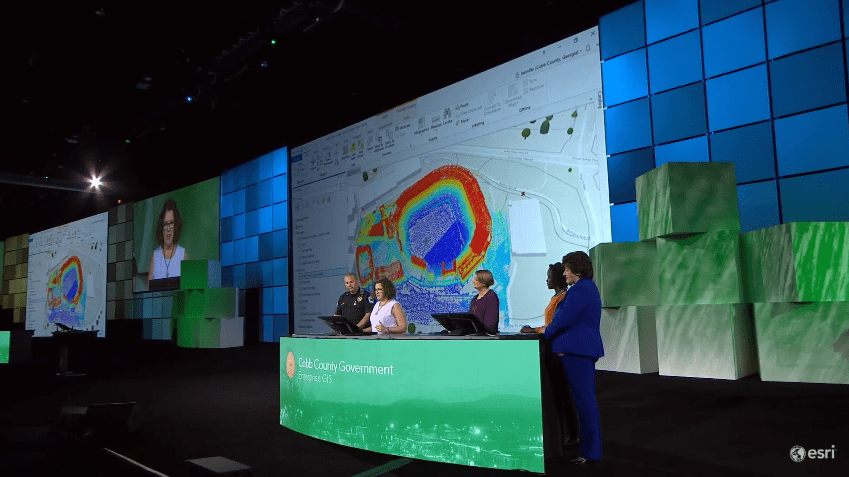
Above: Jennifer Lana, GIS Manager for Cobb County, GA, showcases the County’s application of LiDAR provided by Platinum Geomatics. Pictured behind Lana is a point cloud of the Atlanta Braves Stadium.
At Esri’s annual User Conference, a team of five Cobb County Government employees exhibited how a strong foundation of enterprise GIS has enabled the County to innovate its service delivery through improved location intelligence. The presentation details how the County’s enterprise GIS garnered executive support, distributed the value of GIS across the organization and inspired a new era of problem-solving in the County. “We wanted to leverage GIS as a common platform, to connect across departments – to help us all do our jobs better,” Stanley said.

Director of Information Services Department, Sharon Stanley, introduces the team that presented at the Esri User Conference: “We’re an enterprise GIS, powered by big data, amazing applications, and an incredible group of people.”
After a Story Map providing a virtual tour of County breweries and distilleries caught the attention of tourists and County Executives alike, conversations among County Government employees incited new uses of spatial data to improve delivery of government functions.
Felicia Alingu, a public health specialist, detailed how she uses GIS and Esri’s Insights in senior services. With a steadily rising senior population in Cobb, the Senior Services department is “always wondering how [they] can increase participation at their centers,” and Alingu displayed how GIS has allowed the County to visualize seniors’ participation in events at Senior Centers around the county.

Pictured Right to Left: Felicia Alingu, Lynn Biggs, Jennifer Lana, and Lt. JD Lorens.
Cobb County Department of Transportation Supervisor, Lynn Biggs, then spoke about how enterprise GIS has enabled the County’s DOT to improve its service delivery. Biggs exhibited Cobb Commute, the app that provides County residents with up-to-date information on accidents, road closures, and other traffic information. Biggs also detailed how the County is using enterprise GIS to prioritize roadway improvement projects.
Jennifer Lana, Cobb’s GIS Manager, then showcased how enterprise GIS has brought the county’s various GIS applications together. Using data the County already had, its GIS team created a digital model of the new Atlanta Braves stadium and the surrounding area. Not only has this work allowed the GIS team to be involved in future planning, but it has also enabled the team to bring GIS to users beyond GIS professionals.
Next, Lieutenant J.D. Lorens described how enterprise GIS and the digital model described by Lana shaped a comprehensive traffic management plan with the goal of “parking all of the fans before the first pitch, and then returning traffic to normal operations within 45 minutes after”.

Pictured Left to Right: Cobb County Chief of Police, Michael Register, Director of Public Safety, Sam Heaton, and District Commissioner, Bob Ott. The three attended the conference to learn how to further expand Cobb County’s use of GIS.
Watch the full video of Cobb County Government’s presentation at Esri’s User Conference here. (All images sourced from video.)

